


Four Guides, Four Sets of Dates: What the Maldives Monsoon Season Actually Does
At the country’s southernmost weather station, on Gan in Addu Atoll, the wettest month of the year is December. That is the month almost every travel article files under “dry season” and every resort prices as peak. The Maldives monsoon season is not one thing happening to one place. It is a wind reversal crossing an archipelago 870 kilometres long, reaching each end of it at a different time. The Maldives Meteorological Service does not even class December as part of a monsoon season at all. This article gives you three things: the dates the Met office actually uses, the single rule that predicts water clarity on any atoll, and the indigenous calendar that measures the year in fortnights.
Two winds, not two climates: what the monsoon actually reverses
Strip away the brochure language and the system is simple. The Asian landmass heats up in the northern summer and cools in the northern winter. That pressure difference drags wind across the Indian Ocean first one way, then the other, and the Maldives sits in the middle of the swing.
Maldivians name the two halves of the monsoon season. Iruvai is the northeast monsoon, the drier one, when wind arrives from the northeast and the old sailing route to the subcontinent opens. Hulhangu is the southwest monsoon, the wetter one, when wind comes from the west and southwest.
What does not change is temperature. The Maldives Meteorological Service puts the average range at 25 °C to 32 °C across the whole year. The national record high is 36.0 °C, set at Kadhdhoo on 12 September 1991. The record low is 18.2 °C, at Hanimaadhoo on 23 December 2002. Decades of records, and the two extremes sit eighteen degrees apart.
So “season” here does not mean warm and cold. In the Maldives monsoon season means wind direction, wave height, water clarity and where the plankton goes. Everything a traveller notices follows from those four things.
The official monsoon dates, and why no two sources agree on them
Ask four sources when the dry season runs and you get four answers, and that is not sloppiness. Four different institutions are drawing the line in four different places, for four different reasons.
| Source | Dry / northeast | Wet / southwest | Neither |
|---|---|---|---|
| Maldives Meteorological Service, current | January – March | mid-May – November | December, April |
| Department of Meteorology, earlier demarcation | December – March | April – November | — |
| Nakaiy calendar (indigenous) | 10 Dec – 7 Apr | 8 Apr – 9 Dec | — |
| Typical travel guide | November/December – April | May – October/November | — |
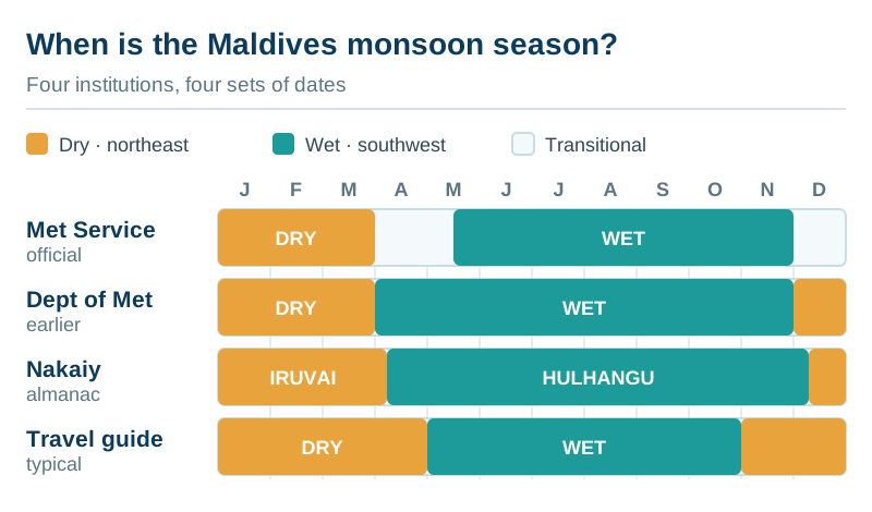
The Met office position is the strictest and the least quoted. Its climate page dates the southwest monsoon from mid-May to November and the northeast monsoon from January to March. It then classes December and April as monsoon transitional periods. Two of the twelve months belong to neither season, and one of them is the most booked month of the Maldivian year.
That matters because onset is declared, not scheduled. The Met office watches for measurable conditions and announces the change when they appear. For the northeast monsoon it looks for winds swinging easterly, exceeding 10 knots, and holding for two or more consecutive days. The southwest monsoon uses a combined rainfall and wind threshold instead. In 2026 the office confirmed onset once more than 60 percent of southern stations had logged daily rainfall above 2.5 mm alongside southwest-to-westerly winds above 10 knots.
Those declarations move around a great deal. The southwest monsoon was declared over the Maldives on 8 May 2026, starting in the south. The northeast monsoon of 2025 did not begin until 2 January, the latest onset in the Met office’s records. A year later it arrived earliest in five years. The dates in the table describe a long-run average, not a promise about your week.
The practical reading is unglamorous but useful. Treat November, December, April and May as swing months whose character is decided fresh each year. Treat February and March as the only stretch of the monsoon season that behaves the same way almost every time.
The rule that predicts your water: clear upwind, plankton downwind
This is the section worth the read, and almost nobody publishes it plainly. One rule tells you what the water will look like on any atoll in any month, and it falls straight out of the wind.
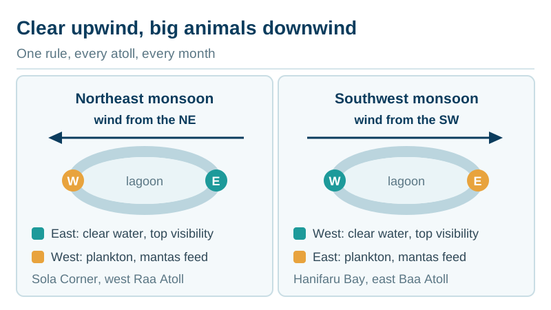
Wind dragging across the ocean surface pushes water with it. During the northeast monsoon the resulting current runs broadly east to west across the archipelago. During the southwest monsoon it runs west to east. Measured strength is modest, roughly 0.2 to 0.5 knots, but it is relentless and it decides where the food is.
The result is a two-sided atoll. On the upwind side clear oceanic water pushes in through the channels, so visibility there is at its best. On the downwind side that water exits again, carrying everything the atoll has stirred up, and plankton concentrates there. Plankton is why mantas and whale sharks turn up. Visibility drops on exactly the side where the animals gather.
So the rule is: clear water on the side the wind comes from, big animals on the side it goes to. During the northeast monsoon that means clear east and plankton west; during the southwest monsoon the sides flip.
Named sites bear it out on both halves of the calendar. Manta Point on the east coast of North Malé Atoll fires during the southwest monsoon. Sola Corner, on the western edge of Raa Atoll, draws mantas during the northeast monsoon instead. Fushifaru Thila in Lhaviyani Atoll is one of the rare cleaning stations that works in both monsoon seasons.
Hanifaru Bay sits on the eastern rim of Baa Atoll. That position is exactly why its season runs May to November rather than in the dry months, as the manta ray season guide sets out. The whale sharks of South Ari Atoll shift the same way. They gather near Dhigurah on the eastern side during the wet months and move southwest in the dry ones, a pattern the whale shark season guide tracks atoll by atoll.
One question turns this rule into a booking decision. Which way does the house reef face? A west-facing house reef in February and an east-facing one in August deliver much the same holiday. Reverse either and you have swapped clarity for animals without meaning to. Our atoll selection guide and the diving season calendar take the rule down to individual sites.
Rainfall runs north to south, not just dry to wet
The second thing guides flatten is geography. The Maldives runs from roughly 7° north to below the equator, and the Met office treats it as three climate regions with three different rainfall regimes.
The annual totals are not close: northern atolls average about 1,779 mm a year, central atolls 1,966 mm and southern atolls 2,218 mm. Take the extreme stations rather than the regional means and the gap widens further: roughly 1,700 mm at Hanimaadhoo in the far north against about 2,350 mm at Gan in the far south. The south absorbs around a third more rain than the north, every single year.
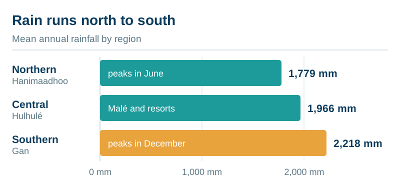
Timing differs more than volume does. Northern stations peak in June, in the thick of the southwest monsoon, which is what everyone expects. Southern stations peak in December. The Inter-Tropical Convergence Zone sits over the southern Maldives through December and January and parks its rain there. February and March are the driest months nationally, and that is the one point where every source converges.
Two things follow for a traveller. The first is that a Malé forecast is not valid for the deep south, so if you are heading to Addu Atoll, Fuvahmulah or Gaafu Dhaalu, read the forecast for Gan instead. That also applies if you arrive through Gan International Airport rather than Velana.
And “December is dry season” is simply wrong for the southern third of the country. It holds in the north, where Hanimaadhoo is the gateway airport. Our December guide treats the two ends of the country separately for exactly this reason. For scale on the extremes, the heaviest 24-hour rainfall the country has recorded is 228 mm, at the meteorological office in Addu City on 24 November 2015.
What wet-season rain looks like from a villa deck
The word “monsoon” does most of the damage here. It imports an image of grey weeks from somewhere else entirely. The Met office description is deliberately flat: rainfall normally comes in showery form, does not last long, and there are sunny periods in between.
Sunshine figures carry the argument better than adjectives can. The Maldives averages 10 to 11 hours of sunshine a day in January, February and March, and 7 to 9 hours in every other month of the year. The gap between the best month and the worst is two to three hours a day. Rain days climb from a handful in February to around fifteen in the wettest months. A rain day is a day with rain in it, not a day of rain.
What genuinely changes is the sea. Wind speed peaks in the north in June and in the far south in December. June and July bring the roughest conditions of the year across the central atolls. Choppy water means shorter inshore visibility, cancelled snorkelling drops and a bumpier ride to anywhere.
That is the honest trade of the wet monsoon season. You are not buying rain instead of sun. You are buying wind, swell and unpredictability, in exchange for mantas, whale sharks and a rate card that can halve. The high season and low season comparison puts numbers on the second half of that sentence.
Where the monsoon reaches your itinerary
Weather stops being abstract at the transfer desk. Seaplanes in the Maldives fly in daylight only, roughly 06:00 to 16:30, and low cloud or heavy squalls ground them as readily as darkness does. A wet-season afternoon arrival therefore carries more delay risk than the same flight in February. The seaplane transfer guide and the overnight-in-Malé guide cover what that costs you.
Boats fare a little better, because rough seas usually reschedule a speedboat crossing rather than cancel it. That mostly means waiting, and the speedboat transfer guide explains why departure times are not yours to choose. If your resort needs a domestic flight plus a boat, you have two weather-dependent legs rather than one. The transfer comparison sets out which resorts fall into which pattern.
Then there is the detail nobody warns you about: the beach moves. Rougher seas during the southwest monsoon strip sand from exposed western shores and deposit it on eastern shores and in sheltered lagoons. Maldivian islands have always redistributed themselves this way, seasonally and naturally.
The consequence for a guest is concrete. The wide beach in the photograph may have been shot in the other monsoon season. In July that same stretch can be a fraction of its width, while the far side of the island has gained what it lost. Ask which side the resort’s main beach faces before assuming the picture holds year-round. Our reporting on whether the Maldives is sinking explains where seasonal movement ends and permanent loss begins.
One correction on storms is worth making here. The archipelago sits outside the main track of Indian Ocean cyclones, which is why the “no hurricanes” line gets repeated so often. Storms and cyclonic systems do still influence rainfall along the northern islands. The 2004 tsunami had nothing to do with weather, and conflating the two is a common error. Low cyclone risk is accurate; no severe weather is not.
Nakaiy: the calendar that measures the year in fortnights
Every guide mentions the nakaiy calendar, and almost none of them prints it. The nakaiy system divides the year into 27 periods of 13 or 14 days. Each carries its own expected weather, wind and fishing character, and the system has roots traced back to the Indus Valley civilisation. Maldivians used it to decide when to sail, when to plant and when to build.
The switch between the two monsoon seasons has its own marker. Bihuroazu falls on 14 April, the seventh day of the Assidha nakaiy. “Bihuroazu is a day of blessings. This region celebrates the day as the new year of monsoons,” the astronomer and historian Abdulla Rasheed told the Maldives Independent in May 2026. He added that he has noticed rain on 14 April in each of the past several years.
Sources split on where Hulhangu formally begins. Rasheed describes it as running from Kethi to Hei, 6 May to 31 October. The published Nakaiy Nevi calendar starts it earlier, at Assidha on 8 April, giving nine nakaiy to Iruvai and eighteen to Hulhangu. Both place the turn between early April and early May, which is precisely the window the Met office labels transitional.
A visitor should care about this because of resolution. Maldivian weather changes on a fortnightly rhythm rather than a monthly one, and a calendar built in fortnights describes the monsoon season better than one built in months.
| # | Nakaiy | Dates | Monsoon |
|---|---|---|---|
| 1 | Mula | 10 Dec – 22 Dec | Iruvai |
| 2 | Furahalha | 23 Dec – 5 Jan | Iruvai |
| 3 | Uthura-halha | 6 Jan – 18 Jan | Iruvai |
| 4 | Huvan | 19 Jan – 31 Jan | Iruvai |
| 5 | Dhinasha | 1 Feb – 13 Feb | Iruvai |
| 6 | Hiyavihaa | 14 Feb – 26 Feb | Iruvai |
| 7 | Fura-badhuruva | 27 Feb – 11 Mar | Iruvai |
| 8 | Fas-badhuruva | 12 Mar – 25 Mar | Iruvai |
| 9 | Reyva | 26 Mar – 7 Apr | Iruvai |
| 10 | Assidha | 8 Apr – 21 Apr | Hulhangu |
| 11 | Burunu | 22 Apr – 5 May | Hulhangu |
| 12 | Kethi | 6 May – 19 May | Hulhangu |
| 13 | Roanu | 20 May – 2 Jun | Hulhangu |
| 14 | Miahelli | 3 Jun – 16 Jun | Hulhangu |
| 15 | Adha | 17 Jun – 30 Jun | Hulhangu |
| 16 | Funoas | 1 Jul – 14 Jul | Hulhangu |
| 17 | Fus | 15 Jul – 28 Jul | Hulhangu |
| 18 | Ahuliha | 29 Jul – 10 Aug | Hulhangu |
| 19 | Maa | 11 Aug – 23 Aug | Hulhangu |
| 20 | Fura | 24 Aug – 6 Sep | Hulhangu |
| 21 | Uthura | 7 Sep – 20 Sep | Hulhangu |
| 22 | Atha | 21 Sep – 3 Oct | Hulhangu |
| 23 | Hitha | 4 Oct – 17 Oct | Hulhangu |
| 24 | Hei | 18 Oct – 31 Oct | Hulhangu |
| 25 | Vihaa | 1 Nov – 13 Nov | Hulhangu |
| 26 | Nora | 14 Nov – 26 Nov | Hulhangu |
| 27 | Dhosha | 27 Nov – 9 Dec | Hulhangu |
Dates are fixed to the Gregorian calendar and repeat annually. The rhythms that grew around them still surface in the national calendar. Fishermen’s Day on 10 December opens the first nakaiy of Iruvai almost to the day, and the public holidays calendar maps the rest of the year.
What the 2026 outlook says, and what it cannot tell you
Seasonal forecasting has improved enough to be worth reading and not enough to plan a week around. The 34th South Asian Climate Outlook Forum met in the Maldives at the end of April 2026. Its assessment for June to September 2026 was below-normal rainfall over most of South Asia. North-western, north-eastern and parts of the southern region were flagged as likely to see normal to above-normal rain instead.
The Maldives sits inside that southern band, which is why national coverage reported a wetter-than-usual monsoon season outlook while the regional headline said the opposite. Both are describing the same document.
The forum flagged two drivers behind that split. El Niño conditions were considered likely to develop during the 2026 monsoon season. The Indian Ocean Dipole, neutral at the time, was expected to turn positive later in the season. Climate specialist Ahmed Shabin told the Maldives Independent that an El Niño takes roughly three to four months to show up in Maldivian conditions. A positive Dipole amplifies that effect; a negative one damps it.
The reef consequence is the one to watch. Both drivers push sea surface temperatures up, and elevated temperatures are what trigger bleaching. The Maldives went through its worst recorded event between 2023 and 2025. Our assessment of reef health after the fourth bleaching event covers what that means for what you will see underwater.
None of this forecasts your holiday. A seasonal outlook assigns probabilities to three-month averages across a region. It cannot tell you whether the second Tuesday of your trip is a washout.
Who should book which monsoon season
Book Iruvai — roughly January to March, plus the settled halves of December and April — if:
- this is your one trip and you cannot repeat it
- you have five nights or fewer
- your resort is reached by seaplane
- flat lagoon water and underwater photography matter more than big animals
- you are travelling with young children and want predictable transfers
Christmas and New Year sit inside this window and price accordingly, as does most honeymoon demand. If you want the best of it without the festive premium, February is the month to look at first.
Book Hulhangu — roughly late May to November — if:
- mantas or whale sharks are the actual point of the trip
- you have ten nights or more, so one lost day costs proportionally less
- budget is a real constraint rather than a preference
- you surf, since the southwest swell is what makes the breaks work at all
The surf season calendar maps that swell window break by break, and it is the same window that produces the Four Seasons Surfing Champions Trophy and the Dhivehi Surf League.
Do not book Hulhangu if:
- your trip is four nights or shorter
- your resort is a far-atoll seaplane property and your outbound flight leaves no buffer
- you have one excursion you travelled specifically to do, with no second chance at it
- you need the beach in the brochure to be the beach you get
And do not assume December is the dry month if you are heading south. In Addu it is the wettest one of the year.
Frequently asked questions
When is monsoon season in the Maldives? The Maldives Meteorological Service dates the southwest monsoon, hulhangu, from mid-May to November, and the northeast monsoon, iruvai, from January to March. December and April are officially transitional and belong to neither. Travel guides usually stretch the dry season to November–April, which is looser than the Met office allows.
Does it rain all day during the wet season? No. Rainfall normally arrives as showers with sunny periods between them. Even in the wettest months the country averages 7 to 9 hours of sunshine a day, against 10 to 11 hours in January to March.
Which month has the best weather? February and March, without much argument, because they are the driest months nationally, the sunniest and the most settled for sea conditions, and they are priced accordingly.
Is the wet monsoon season a bad time to visit? Not inherently. It is the manta and whale shark season, rates fall sharply, and islands are quieter. It is a poor choice for very short trips, for tight seaplane connections, and for anyone with a single unrepeatable excursion booked.
Do the two monsoons affect diving differently? Yes, and predictably. Visibility is best on the side of the atoll the wind arrives from, while plankton and the animals that feed on it gather on the opposite side. The sides swap when the monsoon does.
Are there cyclones in the Maldives? The archipelago lies outside the main Indian Ocean cyclone track, so direct hits are rare. Storms and cyclonic systems still influence rainfall, particularly across the northern atolls. Low risk is not zero risk.
Is the monsoon season the same across the whole country? No. Northern atolls average about 1,779 mm of rain a year and southern atolls about 2,218 mm. The peaks fall in different months too — June in the north, December in the south. A Malé forecast does not describe Addu.
What is the nakaiy calendar? An indigenous Maldivian almanac dividing the year into 27 periods of 13 or 14 days, each with an expected weather and fishing character. It is still referenced alongside modern forecasts, and Maldivian media quote it every fortnight.
The short version
- The Met office recognises two monsoons and two transitional months. Iruvai runs January to March, hulhangu mid-May to November, and December and April belong to neither.
- Onset is declared against measured wind and rainfall thresholds, so the dates move. The southwest monsoon arrived on 8 May in 2026; the northeast monsoon of 2025 held off until 2 January.
- One rule covers water clarity everywhere: clear on the side the wind comes from, plankton and big animals on the side it goes to, swapping twice a year.
- The country is too long for one answer. The north peaks for rain in June, the south in December, and the south takes about a third more rain annually.
- February and March are the only months of the monsoon season that behave the same way almost every year.
Your next step is the month itself. Pick the one you are considering and read what it actually delivers. Start with the seasons and events hub, or go straight to the shoulder months where the trade-offs bite hardest: April, May, October and November. Then check which transfer your resort assigns you, because in the wet months that is the part of the trip weather actually reaches.
Sources for this article
- Maldives Meteorological Service, “Climate of Maldives” — season definitions, temperature and rainfall records, regional annual rainfall totals, sunshine hours. Retrieved 19 August 2026.
- Maldives Meteorological Service, reported via Sun and edition.mv — declared onset of the southwest monsoon on 8 May 2026 and the criteria applied; northeast monsoon onset of 2 January 2025 recorded as the latest on record; earliest onset in five years in December 2025.
- Maldives Independent, “The day Iruvai ended”, 19 May 2026 — nakaiy calendar structure, bihuroazu, interviews with Abdulla Rasheed and Ahmed Shabin, seasonal sand movement between shores.
- 34th South Asian Climate Outlook Forum (SASCOF-34), outlook statement for June–September 2026 — regional rainfall outlook, El Niño and Indian Ocean Dipole assessment.
- Nakaiy Nevi (shaheeilyas.com) — the 27-nakaiy calendar and its fixed Gregorian dates.
- Tropical climate profile of the Maldives, drawing on Maldivian Department of Meteorology station data for Hanimaadhoo, Hulhulé, Kadhdhoo and Gan — regional rainfall regimes, monthly peaks, wind climatology, cyclonic influence on the northern atolls.
- ZuBlu and published dive-site documentation — monsoon-side behaviour of named manta and whale shark cleaning stations.